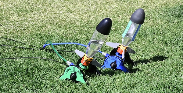
We know our water rockets fly high – very high! But how do we know for sure how high they go? We measure the altitude, or distance to apogee, using a variety of methods.
First up, some terms:
Altitude: A measure of how high your rocket flew above sea level.
Apogee: The point when the rocket is furthest from earth, its highest point. So, after our rockets have run out of thrust (push force) heading skyward, the point where gravity wins and starts pulling the rocket back to earth – that is the apogee.
Measuring altitude – for Prep/Foundation students
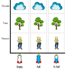
For our littlest engineers, we keep it simple. The Australian Curriculum in Mathematics encourages students to make measurements using everyday items for comparison. So, we ask our students: does the rocket fly higher than a person? A tree? Or into the clouds? At optimum flight, the answer is usually ‘in the clouds’.
Then of course we’ll get students to experiment with how much ‘rocket fuel’ (water) to use—what impact does this have on height of our rocket flight?
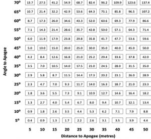
Taking measurements and calculating altitude
We give your older students some tools to calculate altitude. Using our rocket launch pads and a measuring wheel, students can record data and interpret a calculation table to find out how high their rocket flew. Follow these simple steps to calculate your rocket flight altitude:
Step 1:
Measure your angle to apogee, using an instrument such as a clinometer.
Step 2:
Use a measuring wheel to measure the distance from launchpad to landing. Divide this number by 2. This is your distance to apogee.
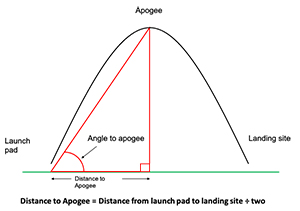
Step 3:
Cross reference your angle and distance into our Altitude Calculation Table to determine how high your rocket flew.
This workshop is great for students to get their hands on a rocket, actually feel the difference in mass when different water quantities are used, physically measure the changes in performance. Then back in the classroom, graph and analyse the results.
So, without realising it, your students practice:
- fair testing
- measuring angles and distances (scaled instruments)
- recording scientific data
- table interpretation
We provide the altitude calculation table on our online e-learning portal for It’s Rocket Science In A Box and walk students through the process in our altitude focused STEM incursions.
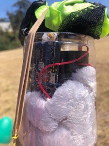
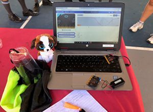
Using digital technology to record flight
Using a payload bay and our parachute recovery system for safe return to earth, we use instruments like the Altimeter 3, micro:bit or enviro:bit to record the flight data of our water rocket launch. For example, the Altimeter 3 will record the altitude, speed, acceleration of the rocket, then using Bluetooth will graphically display this data on your smart device.
 Integrating the digital technology curriculum with fair-testing experiments helps students to see how the excitement of real rocket flights in front of them translates to digital and graphical representation of data.
 So how do we know our rockets fly into the clouds, across the oval or 60 metres into the air? We observe, measure and record our results. Ask us about our workshop Go For Altitude – we’d love to have some learning fun with your students.